
Evapotranspiration is the natural loss of water from soil, vegetation and open water surfaces and release as water vapor to the atmosphere. The volume of evapotranspiration is the sum of evaporation and transpiration. Evaporation is the volume of water loss due to direct vaporization of water from the soil or from an open water surface. Transpiration is the indirect transportation of water from the soil through the vegetation to the atmosphere as water vapor. Evapotranspiration (ET) is a major component of water balance in South Florida. The accuracy of evapotranspiration estimates affects the accuracy of water demand predictions, water supply forecasts, and assessments of impacts of changes in land use and policies.
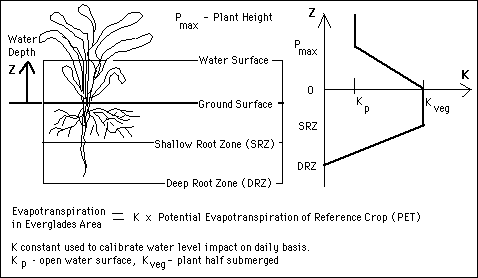
The SFWMM uses different methods of calculating evapotranspiration depending on the characteristics of the land surface. The Everglades Area calculations takes into consideration that the surface is covered with shallow water (water deptth denoted as Z) and contains partially submerged plants. The height of the plant, depth of the Shallow Root Zone (SRZ) and the Deep Root Zone affect the soil hydraulic conductivity,. The effect of changes in water level on evapotranspiration is captured in the calculation of the constant K. If the plants are completely submerged then the conductivity equals the conductivity of the open water surface, Kp, i.e transpiration does not contribute to the evapotranspiration of the area. If the water level is in the Shallow Root Zone then the conductivity is depends on the soil type and vegetation, Kveg. If the plant is partially submerged the conductivity is a linear interpolation of the conductivity of the pond and the conductivity of the vegetation. If the water level is in the Deep Root Zone, the conductivity is a linear interpolation of the conductivity of the vegetation and zero. The Evapotranspiration in the Everglades Area is the product of the conductivity and the potential evapotranspiration of the reference crop (grass).
In the Lower East Coast there are different calculations for non-irrigated and irrigated areas. The calculations from the non-irrigated areas, see Figure 15, are similar to those of the Everglades Area except that the conductivity if the water level is above the Land Surface Elevation (LSEL) is set to zero.
The calculations from the irrigated areas of the Lower East Coast use a much more complex model, see Figure 14. It utilizes a prepropressor, ET/Recharge, to calculate the evapotranspiration. Although ET/Recharge Model calculates Recharge, the result is not input to the SFWMM. The SFWMM does its own Recharge calculation. This module obtains time dependent data from the ARC/INFO Database, calculates reference evapotranspiration (daily potential evapotranspiration) using a modified Penman- Monteith Method, and calls the Agricultural Field Scale Irrigation Requirements Simulation Model (AFSIRS) to process time independent data and perform crop root zone water balance on a daily basis to compute irrigation requirements.. The AFSIRS Model calculations are done on a polygon grid or Basic Element Area (BEA) used by the United States Geological Survey to describe the soil (SOIL.DAT), the crops (CROP.DAT) and irrigiation (IR.DAT). The soil database includes soil type (more than 800 categories), associated textures, water holding capacity, depth characteristics and hydraulic conductivity. The crop database contains monthly crop coefficients (the ratio of evapotranspiration for the crop type to the refence evapotranspiration of grass), the irrigated crop root depths, total crop root depth and monthly allowable soil water depletion. The irrigation database describes the irrigation system type, the application efficiency of the irrigation system (EFFa), the percent of irrigated soil surface area, and the fraction of evapotranspiration coming from the irrigated portion of the crop root zone. The AFSIRS Model generates irrigation demand, crop actual evapotranspiration, crop requirements and recharge components. The ET/Recharge Model accumulates the results of the polygon grid to the variable model grid size specified by the user.
If the Lower East Coast Developed Area cell is ponded, then the main source of evapotranspiration is the pond. The evapotranspiration rate from ponding will be the open-water rate. Potential evapotranspiration, PET, is adjusted to represent the potential evapotranspiration for an inundated cell. Evapotranspiration from the unsaturated zone needs to be recomputed so that the maximum allowed evapotranspiration is the value of PET. South Florida Water Management Model accounts for unzaturated zone evapotranspiration in this scenario as being part of the evaporation rate from ponding.
	PET = PETo * 1.4

	ETP = max(PONDING, PET)

	PONDING = PONDING - ETP - ETU

	... (additional code for all possible cases)
where PETo is the reference evapotranspiration of grass from the ET/Recharge Model, PONDING is the ponding depth, and ETP is the evapotranspiration from ponding.
Maximum evapotranspiration, ETMAX, and total evapotranspiration, ETTOT, also varies by type of surface area. Over a Free Water Surface the MODFLOW model assumes:
	ETMAX(Free Water Surface) = Potential Evaporation, and

	ETTOT(Free Water Surface) = ETSAT = ~ Potential Evapotranspiration(Free Water Surface),
In Impervious Areas, evaporation from the unsaturated zone is very negligible
	ETMAX(Impervious Areas) = 0.0, and

	ETTOT(Impervious Areas) = ETUNS, where

	ETUNS(Impervious Areas) = min ( Rainfall, Ia),
where Ia is the Initial Abstraction value calculated to be equal to 0.07 in of initial surface retention and the abstraction cannot be larger than the actual rainfall.
In Pervious Areas,

	ETMAX(Pervious Areas) = ETP - ETUNS,
where ETP is the evapotranspiration from ponding and ETUNS is the evapotranspiration computed by the Agricultural Field Scale Irrigation Requirements Simulation (AFSIRS) model, taking into account the infiltration.
Figure 14. Evapotranspiration in Everglades Area in SFWMM and NSM
Figure 15. Evapotranspiration in Non-Irrigated Areas of the Lower East Coast
Figure 16. Evapotranspiration in Irrigated Cells of Lower East Coast developed areas, preprocessing irrigation demand
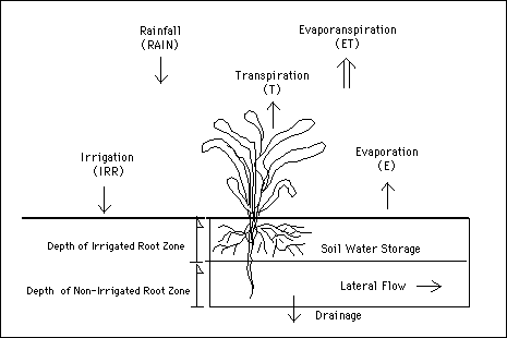
Figure 17. Components of the water budget of a crop root zone in AFSIRS Model

 Feedback: Home page maintained by Gopal Raghavan.
 Back to Home Page
 Table of Contents
 List of Figures
 Acronyms
 Previous Page
 Next Page
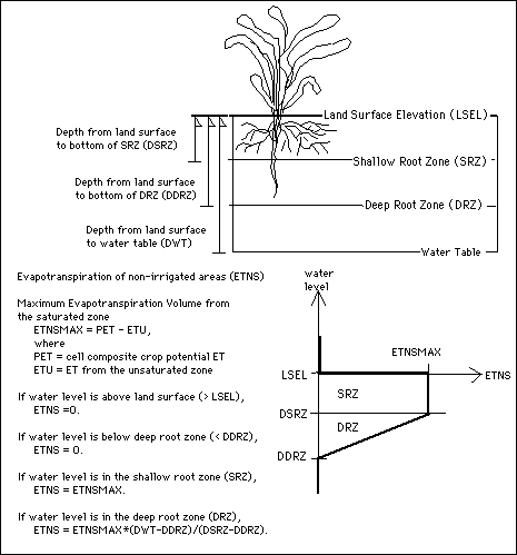