
Lake Okeechobee is the main component of the Central and Southern Florida Flood Control designed and constructed by the U.S. Army Corps of Engineers. The Lake Service Area is separated into five distinct basins: North Shore, Caloosahatchee River Basin, St. Lucie River Basin, Lower East Coast, and Everglades Agricultural Area. The lake receives a large volume of runoff from the Kissimmee River and the Upper Chain of Lakes, Lake Istokpoga and other inflows along the North Shore during the wet season. During extended periods of drought the runoff from these areas are insignificant.
The lake has regulated minimum and maximum control levels that establish the maximum safe storage considering the tropical nature of storms in south Florida during the late summer, and the minimum safe storage required to prevent sea water intrusion and reduce salinity, and to address the irrigation demands of the Everglades Agricultural Area and, during prolonged drought periods, the Lower East Coast. During a normal rainfall year the urban users of the Lower East Coast would likely not require supplemental water from Lake Okeechobee because its average annual rainfall of 59.2 inches is 10 inches per year higher than the Agricultural Area. The lake should not be allowed to reach the maximum levels very frequently because of the negative environmental impact on the littoral (marsh) zone vegetation due to prolonged inundation.
The District's Water Shortage Plan, implemented in 1982, provides specific guidelines for water restrictions (ranging from 15% to 60% cutbacks) based on the type of use and severity of the drought. The Lake Okeechobee Supply-Side Management assumes that
2) Normal rainfall, normal evaporation and normal agricultural water use demands would be utilized for computational purposes
3) A stage of 13.5 feet NGVD on October 1 must be exceeded in order to defer implementation of supply-side management techniques.
Figure 19. Conceptional illustration of Lake Okeechobee Zones - Overhead view
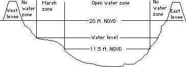
Figure 20. Cross slice illustration of the Lake Okeechobee Zones
Figure 21. A Stage-Area Curve of the Lake Okeechobee Zones
To calculate the delta storage of the lake, the lake is treated as a reservoir:
To study different scenarios that happened historically, the historical water budget is calculated
Figure 22. Simulating New Management Policies with Historical Inflows and Ouflows.
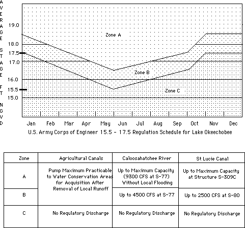
Figure 23. U.S. Army Corps of Engineer 15.5 - 17.5 Regulation Schedule and Regulatory Zones for Lake Okeechobee
The level of Lake Okeechobee is governed by control measures established by the U.S. Army Corps of Engineers and contained in a schedule that is sometimes referred to as the 15.5-17.5 schedule based upon the range of values that may trigger a regulatory discharge. There are three regulatory zones: A, B, and C. Zone C generates no regulatory discharges. Zone B generates releases according to the parameters shown in Figure 23. In Zone A, maximum discharges through all outlets are generated in an effort to bring the stage of the lake down. Because of the negative impact on estuarine ecology, salinity fluctuations and associated siltation when regulatory discharges are done, a Pulse Release Program (also referred to as the Early Release Plan) was formulated by the District, which includes multiple release pattern options for managing the stage of Lake Okeechobee to avoid Zone B discharges. The release pattern is called a pulse because of the natural hydrograph pattern which has to be simulated by the discharges. The pulse release schedule is dictated by a table created by the Environmental Sciences Division and the Water Resources Division of the District in 1988, containing three levels of releases.

 Feedback: Home page maintained by Gopal Raghavan.
 Back to Home Page<
/A>
Back to Home Page<
/A> Table of Contents
 List of Figure
s
List of Figure
s Acronyms
 Previous Page
 Next Page
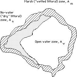